The close knit bond of our Kilkenny Ancestors- a map of our origins in southern Kilkenny
When our ancestors met and married other immigrants from Kilkenny in Jerseyville, they were often familiar with the communities their families came from. Here is a map of the area of southern Kilkenny where most of our ancestral families lived. The closest city was Waterford, just across the river Suir.

From Killinispic, it was only 6 miles to Garryduff, starred in orange in the top left corner of the map, and 4 miles each to the villages of Piltown or Mooncoin. Mullinavat was 5 miles away, and 8 miles to Rahillakeen and Bigwood (starred in orange to the lower right of Mullinavat.)
So we see our ancestors who married into each other's families in Jersey County generally came from a very close communities in Kilkenny, Ireland.
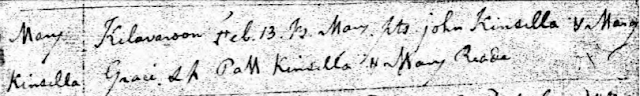
Kinsella's- Killinaspic
Quinn's and Fitzgerald's- Bigwood (Rathnasmolagh) and Rahillakeen
Durney's- Garryduff
It is only the Allen's that came from a distant county 90 miles to the north-Summerhill Parish in County Meath.

Comments
Post a Comment